Featured products
menu item
Prospect
Quick estimate of PV site's solar potential
menu item
Evaluate
Data, design & PV simulation in one solution
menu item
Monitor
Real-time PV output assessment
menu item
Forecast
Solar power output forecast for up to 14 days
Other solutions
menu item
Analyst
Simplified & unified solar data management
menu item
Integrations
Automate delivery of Solargis data
menu item
Solarmaps
Assess weather impact on PV performance
menu item
PV Components Catalog
Technical specifications of PV components
menu item
Use cases
How we support entire PV plant lifecycle
Solar Resource & Meteo Assessment
Detailed solar resource validation and assessment
Site Adaptation of Solargis Models
Combining satellite data with on-site measurements
Quality Control of Solar & Meteo Measurements
Correction of errors in ground-measured data
Customized GIS Data
Customized Solargis GIS data for your applications
PV Energy Yield Assessment
Estimated energy uncertainties and related data inputs
PV Performance Assessment
Energy estimate for refinancing or asset acquisition
PV Variability & Storage Optimization Study
Understand output variability across wide geo regions
Regional Solar Energy Potential Study
Identification of locations for solar power plants
menu item
Prospect
Quick estimate of PV site's solar potential
menu item
Evaluate
Data, design & PV simulation in one solution
menu item
Monitor
Real-time PV output assessment
menu item
Forecast
Solar power output forecast for up to 14 days
Our expertise
How our technology works
Validation and accuracy
How we validate our datasets and models
Methodology
How we transform science into technology
Knowledge base
Release notes
Success stories
Blog
Ebooks & Whitepapers
Webinars
Publications
Events
Free Maps & GIS Data
Collaterals
About Solargis
Partners
ISO Certification
Careers

New generation Solargis Evaluate: data, PV design & simulation, analysis, and reports in one cloud-based solution. Discover more ->

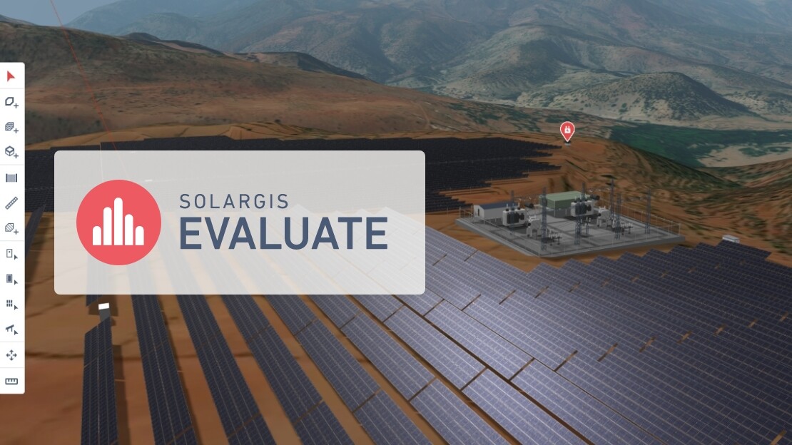
Solargis Evaluate now includes snow losses calculations, providing developers with a more realistic estimate of energy production in regions affected by snowfall. This is one of the latest enhancements in the new Solargis Evaluate platform that we launched in early 2025.

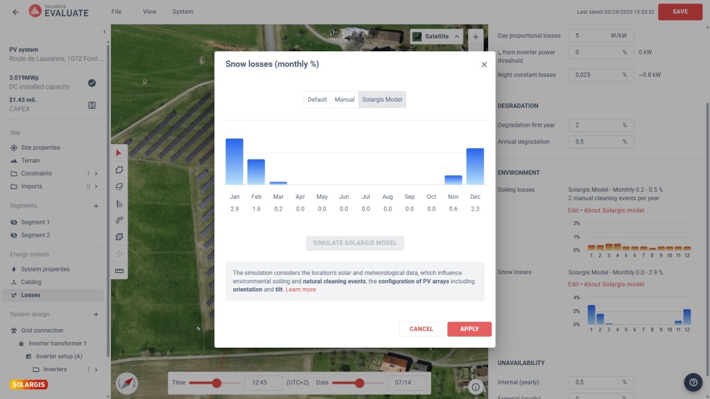
Solargis Evaluate users can now automatically simulate snow losses using the new Solargis snow loss model. This allows for better planning of solar panel maintenance and helps mitigate financial losses caused by snowfall.

As part of the latest release, users can also calculate soiling losses using the Solargis soiling loss model. 

Why is calculating snow losses important for PV performance?

Accumulation of snow on PV modules blocks solar irradiation and leads to power production losses. This is particularly problematic in regions with frequent and prolonged snowfall, such as parts of Europe, North America, and Asia.

For solar operators, accurate forecasting of snow losses is essential to minimizing financial risks. Grid operators and investors require precise energy yield predictions to manage power supply, purchase balancing power, and plan investments in snow-prone areas.

Snow losses MAP

Solargis Evaluate brings smarter approach to snow loss modeling

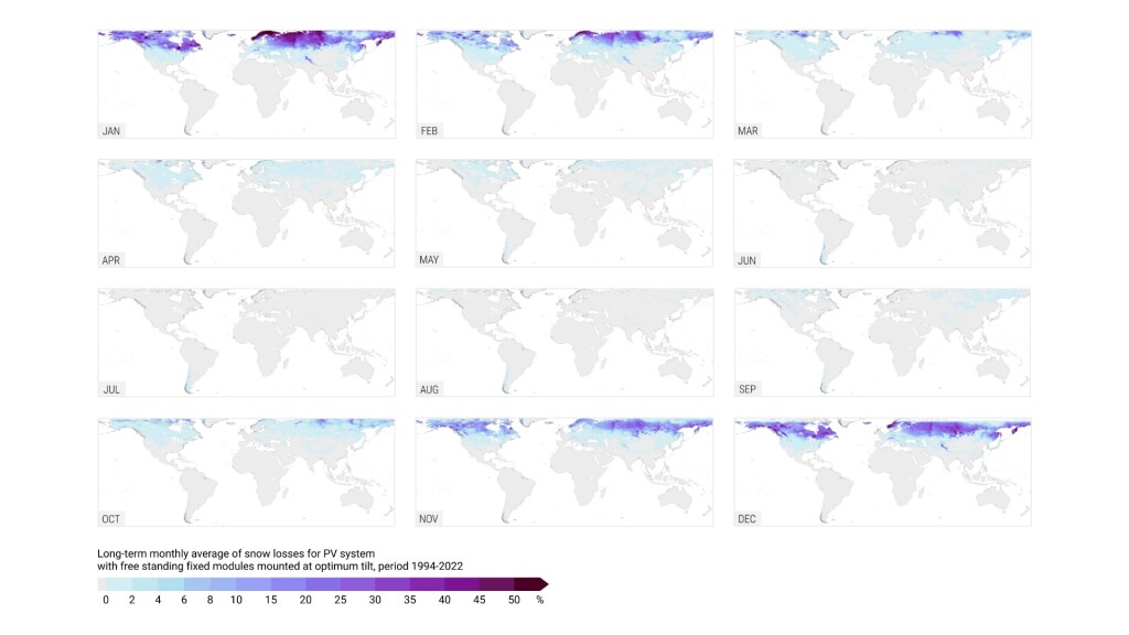
Since snow losses directly impact final PVOUT, Evaluate provides more realistic energy yield predictions, helping prevent PVOUT overestimation.

The Solargis snow loss model integrates data from two leading sources:

  • ERA5 and ERA5-Land – Provides hourly meteorological data such as fresh snow depth and air temperature with spatial resolutions of approximately 31 and 9 kilometers, respectively.
  • Solargis satellite-model solar radiation data – Delivers precise solar radiation data, essential for estimating PV power production under normal conditions.

Solargis complements this with high-resolution global tilted irradiation (GTI) data, which is essential for estimating PV power production and plays a direct role in accelerating snow melting.

Snow loss calculations are performed using 15-minute Time Series, ensuring a detailed temporal resolution.

By combining these datasets, Solargis Evaluate ensures highly accurate snow loss modeling, enabling better planning and risk assessment for solar projects.

When calculating snow losses, Evaluate users can now choose from three options:

  • Snow loss simulation calculated by the Solargis snow loss model
  • Option to manually adjust monthly snow loss values if you prefer your own estimates or have the data measured.
  • Default setting – flat snow losses value (0%)

Energy System Designer Snow Losses

Solargis Evaluate: A new standard for PV project evaluation

By integrating snow loss calculations, Solargis Evaluate enhances the accuracy of PV simulations, helping developers, investors, and grid operators make better-informed decisions. 

The new Evaluate is a more advanced, cloud-based software solution for complete PV project design and evaluation, integrating:

  • High-resolution solar, meteorological, and environmental data
  • 3D PV power plant design module
  • PV components catalog
  • Advanced PV performance simulation
  • Analytical reporting

With climate conditions becoming increasingly unpredictable, precise modeling of environmental factors like snow losses is critical for ensuring financially viable and technically sound projects.

Learn more about the Solargis snow loss model here

Keep reading

Precipitable Water (PWAT) - new data parameter
Solargis news

Precipitable Water (PWAT) - new data parameter

Precipitable water or ‘PWAT’ in short, is the depth of water in a column of the atmosphere if all the water in that column were precipitated as rain.

Training in Beijing: sharing our knowledge with chinese professionals and the public
Solargis news

Training in Beijing: sharing our knowledge with chinese professionals and the public

We shared our knowledge with professionals in the solar energy industry in China during Assessment of solar resource measurement technology exchange event.

Annual average values of solar resource and temperature are now available for free via iMaps
Solargis news

Annual average values of solar resource and temperature are now available for free via iMaps

From today onwards, we are also opening access to long-term annual averages of key solar parameters GHI, DIF, and DNI via Solargis iMaps prospecting tool.